Sunday, June 18, 2017

Another Seward's Folly? OR "I oughter see a Sea Otter!"

We arrived in Seward, Alaska late on Monday Afternoon.  Tuesday (June 13th) we went on a boat tour of Resurrection Bay (the bay in which Seward is located.  This bay is a “fjord.”  “Fjord” is  a Norwegian word for a deep water narrow bay with cliffs or mountains on each side.  They are the result of glaciers that cut the rock away as they advanced during the last ice age.  As the earth warmed 10,000 years ago (it wasn’t caused by man THAT time either! 😜) the sharp walled, narrow gorge left behind came to be called a “fjord” by the Norwegians.  They made for excellent harbors because they were very defensible.  There was only the one entrance (up the gorge) and the side walls made attacking from on high very difficult.  The Resurrection Bay fjord is 950 feet deep in its central channel; about 3 miles wide and 11 miles long (that’s a LOT of melted ice cubes).

A “funny” thing happened when we went on our cruise Tuesday:  We took our Canon EOS 500D camera complete with charged battery – uhhhh, somehow I forgot to put the SD card back into the camera 😱😱 (Sometimes I put the MO in MO-ron)!  So our marvelous camera complete with a 200-500mm hyper-zoom lens became a “uniocular”.  That’s a bi-nocular but for only one eye.  Other than that it was functional only to hold our table down. OOPS!! 😢😭. So, we got what pictures and videos we could with our iPhone 6s.  Unfortunately, there isn’t anything that drains the battery on an iPhone faster than recording videos.

The tour was terrific.  We saw humpback whales, seals, puffins, cormorants and orcas (“killer whales” – though they aren’t whales at all, they are the largest member of the dolphin family) + thousands of “rats with wings” – AKA seagulls.  We also saw Bear Glacier, the largest glacier in the Harding Icefield.   We got what pictures we could given our photographically crippled state.

Ergo, we decided that we would go out AGAIN Thursday, June 15th.  This time we would be “camera-ready.”👍🏻👍🏻. Besides the Canon, I took my iPodPro for videos.  It has a terrific lens on it – 6,000 gazillion megapixels or something like that.   Today we’ve seen a humpback female and calf feeding; seals, orca, puffins and cormorants, kittiwakes and 4 different glaciers – Bear, Holgate, Peterson and Aialik. HUBBA-HUBBA

So, before we get to our picture presentation, I have a couple of “meteorologically incorrect” questions for everyone that is reading this post:  

• About 25,000 years ago much of the northern hemisphere was encased in ice: Alaska; virtually ALL of Canada (in the USA the southernmost remnants of the Canadian icefield are the Great Lakes that, as they melted, became the lakes we know today); All of Scandinavia and even Scotland were all ice covered.  Now then, the question: What caused those glaciers to melt?  It certainly wasn’t the “advancing technology of man” or “man’s use of ‘fossil fuels’” creating “greenhouse gases” to rise the temperature of the earth.   According to scientists (those unassailable paragons of deductive logic) 25,000 – 10,000 years ago mankind was at best loose bands of hunter/gatherers.  Wouldn’t the meteorological phenomena that caused the retreat of this glacial age be, by definition, “global WARMING?”  NO, this was not due to man. What caused it was the forces of the universe: The cycle of increasing and decreasing temperature of the sun itself; Solar Radiation; the earth’s magnetic field collapsing in upon itself and at times reversing; the wobble of the earth on its axis; the natural variance in the earth’s orbital rotation around the sun (Causing increasing perigees and apogees). EXACTLY NONE of these natural phenomena are within the control of man and all even an exceedingly higher effect on the temperature of the earth than man's level of pollutants.  For instance, in the 1783 the Laki fissure system eruption on Iceland spewed forth forth an absolutely MASSIVE amount of ash (14 cubic kilometers or 3.3 cubic miles) into the upper stratosphere.  This led to a winter which averaged 1 degree (Celsius) lower around the northern hemisphere.

• A second confounding posit:  Scientists (yes, once again those unassailable paragons of reason) tell us that at the end of the last ice age, the Sahara Desert was about like it is now:  Except for the area along the Nile river it was desert and largely uninhabitable.  But as it says at the "LiveScience.com" Website:


A timeline of Sahara occupation:
  • 22,000 to 10,500 years ago: The Sahara was devoid of any human occupation outside the Nile Valley and extended 250 miles further south than it does today.
  • 10,500 to 9,000 years ago: Monsoon rains begin sweeping into the Sahara, transforming the region into a habitable area swiftly settled by Nile Valley dwellers. 
  • 9,000 to 7,300 years ago: Continued rains, vegetation growth, and animal migrations lead to well established human settlements, including the introduction of domesticated livestock such as sheep and goats.

  • 7,300 to 5,500 years ago: Retreating monsoonal rains initiate desiccation in the Egyptian Sahara, prompting humans to move to remaining habitable niches in Sudanese Sahara. The end of the rains and return of desert conditions throughout the Sahara after 5,500 coincides with population return to the Nile Valley and the beginning of pharaonic society.
Certainly man's "industry" didn't cause this meteorologic shift is the weather patterns.

That's enough "head scratchers" for our "Global Climate Change" readers for now.

Here are some pictures and videos from the "Seward Swing" of our Alaska trip:


Above: Orcas - typically known as "killer whales" are not actually whales at all.  They are the largest species in the Dolphin family.  They are the most "intelligent" of all the cetaceans (whales, dolphins, porpoises).  Learned behaviors are passed down from parent to young.  The "Pods" are ruled by the oldest female.  She directs everything.  Even telling the males when they can breed and which females they may breed.


Above: A Humpback female and her young.  She is "Lunge Feeding"and teaching her young how to do it also.  Notice the birds, they start to dive toward the water as the massive amounts of krill or small fish are pushed to the surface by the force of the whale swimming toward the surface with its mouth agape.  Interestingly, the weight of the water in the x4 expanding"neck pouch"weighs more than the whale itself.  It then forces the water through the baleen attached to its upper jaw.  The baleen acts as a sieve - holding in the solid (edible stuff) and allowing the water to be ejected by pressure of the contracting "neck pouch."  For all of their size, baleen whales throats are only about the size of a large grapefruit, so the cannot eat large objects.


Above: Two Stellar Sea Lions having a "game" of "king of the hill."  They would appear to be young sea lions.  Not as big as the ones in the movie below.


Above:  This picture above kind of looks like a Stellar Sea Lion version of "the wave" you'd see at a baseball or football game.  Stellar Sea Lions are the largest of the "Eared Seals."  That means that they have small ear flaps next to their earhole opening which they can turn to hone in on the direction from which a sound is coming. 


Above: A picture of a harbor seal relaxing on an ice floe that Irene took near the Aialik glacier.  Seals use them for resting; interacting with one another and spotting prey in the water.  "True Seals" like this harbor seal only have an ear opening on the outside of their heads on each side.  All seals are carnivores eating mainly fish.  They only have pegged teeth, so they have to swallow their food whole OR come to the surface and bite into it and throw their heads back and forth and allow the weight of the prey and gravity to provide the torque to tear the chunk off in its mouth.


Above: For 5 days Irene was on a mission, she wanted pictures of a sea otter and she wanted them last month!!  The otter union must have had a strike vote.  For 3 days at Homer we saw ZERO, zilch, nada, negative bupkis Sea Otters  so we get to Seward and Irene is still "on the prowl."  She's gonna land her some sea otter pictures or we are going to take up residence in the State of Alaska until we do.  Her chant for 5 days was "I oughter see a sea otter."  Finally on our 3rd day in Seward one "scab" otter crossed the picket line and gave Irene her heart's desire:  Not just a "picture" of a sea otter, but what essentially amounted to a one-on-one "sit down interview."  He was 2 feet away and displayed the full ensemble of otter behaviors - floating on his back, spinning, holding a clam in his forepaws as he cracked through the shell with his teeth and ate the insides.


Above: Cormorants - these are piscivores (fish-eaters) that dive into the water and use their wings as "fins" to swim under water and catch their prey.  Interestingly enough, unlike most other piscivore fish they do NOT secrete an oil that keeps their wings from getting wet.  Consequently, between "fishing sessions" they have to get out of the water and let their wings dry out.  That is what the cormorant on the left of this picture is doing.  Lifting their wings off their body and crooking them allows for a maximum of airflow over them which dries them out.


Above:  One of the more hilarious sights to behold is a Puffin trying to take to flight.  Their bodies are made for diving,  to catch fish to eat.  They have to beat those little wings (which make for GREAT fins under water) 300 x per MINUTE to lift themselves out of the water and take flight.  Sometimes they are so tired they just give up and rest more before trying again.


Above: 3 pictures of puffins.  You can see pretty clearly that the top picture is a "tufted" puffin.  That means it has feathers forming a kind of "duck's tail" at the back of its head.  It has a kind of "Fonzi" thing going on, so to say.  In the bottom picture you can see that fat belly which makes flight harder than possible sometimes when its filled with food.


Well, this post is WAYYYYY long enough already.  So, I'll have to save the glacier stuff and geology stuff for the next post.

Friday, June 16, 2017

o/` o/` "Big Jim Left Seattle in the year of '17, with Irene beside him because she is his queen" o/` o/`

Only a few of you old fuddy-duddies might almost recognize that title as a really twisted, highly stylized homage to Johnny Horton's "North to Alaska" released in 1960 shortly after Alaska became a state.  It was the theme song for a movie by the same name which starred John Wayne, Stuart Granger, Ernie Kovacs and Fabian (a bubble-gum singer from the late '50s).


Anyway,  we are in Alaska again this year.  We wanted to come up again to see my sister Franny who became a Christian last year after Irene studied with her while we were at Homer, Alaska.  Fran lives in Sterling Soldotna since she was baptized.  She's lived in Alaska for almost 30 years now.  9 or so in Skagway when she first moved up here, then 10-12 or so in Kodiak and now she lives on the Kenai peninsula.  Well, in all that time she had never been to Denali National Park.  So we took her there when we came up this year.

Here are some pictures:


The 2 pictures above are of my sister Fran and I.  We took the opportunity of being in a unique location and surrounded by God's beauty to "spread" some of our mom's ashes.  This is the bridge over the Seattle Creek on the Old Denali Hwy.


The 3 pictures above are of Ptarmigan.  This is the state bird.  
The top one is a female and the bottom 2 are males.  
They are "Alaskan 'chicken'" essentially.


Above - Ridge beyond ridge of beautiful mountains are commonplace in and around Denali.


Above - an small alpine lake surrounded by Cypress trees. 


Above - the Frozen Tundra.  Above the tree line wide expanses of flat 
terrain which in the spring explodes with beauty.


The above picture shows a "forest" in permafrost.  With the ground frozen beneath them, the trees just can't get enough nutrition to grow large.


Above - part of Polychrome Mountain about 25 miles into Denali from the main entrance.  
It is given much of its color by Rhyolite a volcanic rock.


Above - These 2 pictures are Caribou.  Caribou are the ONLY species in the deer family where both the male and females have antlers, but they drop them a different times of the year.  The females carry there's through the winter and drop them in June or July after they are done breast feeding their young.  The males drop them in November or December.


These are Dall Sheep.


Above - a Young Bull Moose (called "elk" in Europe).  Moose are the largest of the deer family.  Bulls can weigh up to 1500 pounds (about 700 Kg).


Above - A female moose (Europe - "elk").  Females are "cows."  This one had given birth less than 24 hours previously to twins.  She is UPSET that cars keep slowing and stopping to take pictures.  Her back hair (hackles) are straight up and she is ready to charge anything that gives her an excuse at this point.


Above - The less than 24 hour old moose calves.


Above - A picture of one of the moose calves.


Above - a Marmot.  Marmots are essentially large mountain squirrels.  
They live on grass, berries, flowers, moss and lichens.


Above - 2 pictures of a porcupine.  Porcupines are rodents.  Interestingly, porcupines climb trees a lot (I didn't know that).  They can have up to 30,000 quills. Porcupines CANNOT "throw" their quills.   People and dogs (especially) just get too close. They eat wood, bark, flowers and berries.


Above - 3 different grizzly bears we saw.  

Bear safety:
  • Never approach a bear.  Leave 300 yards between you and any bear you see.  Make LOTS of noise to warn them you are coming if you are walking in the woods.
  • Never leave out food of ANY kind in your campground.  It WILL attract any bear in the area.
  • If the bear has NOT seen you yet: Back away FACING the bear. 
  • If the bear HAS seen you and is looking at you: NEVER run from a bear (it is faster than you), and their instinct is to chase prey.  They much more likely to chase something showing running away.  Back away FACING the bear.  Make yourself as BIG as possible (wave your hands above your head) while you shout.  
  • IF the bear charges you:  Make yourself as BIG as possible (wave your hands above your head) while you shout.  Wait to see if it stops, NEVER run from a bear.  Back away FACING the bear.  Many bears do mock charges.
  • If a bear attacks you:
    • If it is a black bear (dog like ears, smaller claws, NO hump on its back) - fight like the dickens:  Punch, grab a stick and to poke at the bear to keep it away, etc.
    • If it is a grizzly bear (small round ears, distinct hump on its back at the shoulder, large claws) - drop to the ground on your stomach.  Protect your neck with your hands or, if you have a back pack pull it up to protect your neck.  If it starts biting - fight like your life depends on it because it does.
Following being at Denali, we had a sojourn at the Soldotna church of Christ.  It's the church that Fran is part of.  It's right about in the middle of the Kenai peninsula.  That's a peninsula just that's on the south side of the Cook Inlet.  [I'll wait while you get a map or look on your phone or computer]. OK, so now you know where the Kenai Peninsula, Cook Inlet, etc. are.

Irene and I were the only couple in the sojourn, so what we could accomplish was somewhat limited.  Still, over 10 days I installed 445 feet of baseboard trim in 7 classrooms, two large open areas, the kitchen and transitional hallway in the basement of the building.  Irene gave a deep cleaning to 2 ovens in the kitchen and 2 refrigerators in the kitchen.  She also deep cleaned bathrooms and applied a weather sealant to a large wooden swing set in the church's play area.

Following the sojourn we went down to Homer, Alaska to visit with the church at which we led a sojourn last year.  It was great to see our brothers and sisters there again.

Then, that evening after Sunday night services we drove to Seward were we are spending this week seeing the sights and MY, OH MY how many sights there are to see here.  More about that in our next post.

Tuesday, May 2, 2017

Port Lavaca, TX

Along the Texas Gulf of Mexico coast is a town of 12,500 people called Port Lavaca.  It's about 2/3 of the way down the coast from houston to Corpus Christi.  Lavaca is Spanish for "The Cow."


The town is "barely making ends meet."  Most of its BIG employers have shut down - The Oil Companies have left; Alcoa left behind an environmental nightmare that is part of the EPA superfund.  You can't swim in the Port Lavaca Bay - the mercury levels are too high.


One large employer in the area Formosa Plastics LITERALLY wants to buy up the little burg of Point Comfort (population 725) across the bay to tear it down to expand their plant.

Port Lavaca has 1 theater with 2 screens that shows movies that came out about a month before they get here.  They are on the cutting edge of the takeover of America by the importing of cheap garbage from China (another way of saying "Port Lavaca has a Walmart").

Interestingly enough, the pelicans and white herons don't seem to find the mercury levels.  There are hundreds of pelicans here.  They are beautiful to watch trying to hover in the air against 25 MPH winds and then suddenly dive bomb into the bay for a fish they hope to catch.  We tried to get some videos of them but the traffic going over the bay bridge is steady enough that you can't slow down to 5-10 MPH while you film them and at 55 MPH you can't keep them in your viewfinder long enough to see much.

I did however get a nice video of a white heron or white egret (ornithology is NOT my strong suit), so here it is below:


Irene and I have come to Port Lavaca for 4 straight years.  The last 3, we have been the team leaders of the Sojourn here.  This year they wanted me to teach the book of Revelation.  I've taught it a LOT over the last 20 years.  I used to teach Daniel, Ezekiel, Revelation and Jeremiah at the Cape School of Preaching in Athlone (a suburb of Cape Town, South Africa).

I'm doing it in 6 lessons.

Sunday Morning Bible Class:  Chapter 1 & Chapter 22:6-16 - How God Says to interpret the Book
Sunday Morning Sermon:  Chapter 2 - 5:14 - Churches - Prepare for the Judgment that's Coming
Sunday Evening Sermon:  Chapter 6 - 10:11 - God’s People Call for Justice
Monday Evening Lesson:  Chapter 11:1 - 16:21 - The Judgement of the Enemies of God’s People
Tuesday Evening Lesson:  Chapter 17:1 - 19:21 - God Answers His People’s Calls for Justice
Wednesday Evening Lesson: Chapters 20-22 - The New Heaven and the New Earth and the New City Comes Down

I've given everybody that's attending a copy of the notes that I used when I taught Revelation - all 73 pages of them.  They are VERY exhaustive.

If you've ever wanted to study the book of Revelation, send me an email.  I can email you then Microsoft Word Document of my notes of Revelation (and Daniel and Ezekiel also if you want).

Send me an email at: exactcopies@reagan.com

There is NO CHARGE for the notes.

Saturday, April 1, 2017

West Texas has NOTHING on Namibia when it comes to "Miles and Miles of Miles and Miles!"

We are finishing our visit to the region of Southern Africa with 5 days in the country of Namibia.  We came here to work with the Church of Christ in Keetmanshoop.  This town is the Capital City of the Karas Region of Namibia.

The country of Namibia is old German Southwest Africa.  It was given up by Germany following its loss in World War I in 1918 and made a protectorate of South Africa by the League of Nations.   Following World War II the United Nations asked South Africa to make the area a protectorate of the UN.  However, South Africa refused to recognize the UN request and ruled Namibia as a proxy state. Finally the UN passed a mandate in 1968 that formed the nation of Namibia.  No problem, South Africa refused to recognize the UN mandate also and continued to rule Namibia by force of arms.  This led to the rise of SWAPO the "South West Africa People's Organization" a revolutionary (largely Marxist in belief) that fought for independence from South Africa.  South Africa rule by force including instituting the doctrine of "Apartheid" or "Apartness" -- meaning forced separation of races and assignment of living areas by the whites in control of South Africa's national government. Finally, after 20 years of revolution and the Global institution of trade sanctions against South Africa (during the Reagan Administration), South Africa in 1988 recognized Namibia as a separate country.

Virtually ALL of Namibia is desert "technically speaking."  Some of it rivals the great deserts of the world - miles and miles of sand.  A great deal of it reminds me of "West Texas ... with mountains."  The most northerly section of Namibia (which is the wettest and the major agricultural region of the nation) receives 450-550 ml of rain per year.  That is 45-55 centimeters which is ~ 18-21 inches of rainfall per year - and average of 1.5-1.75 inches per month.


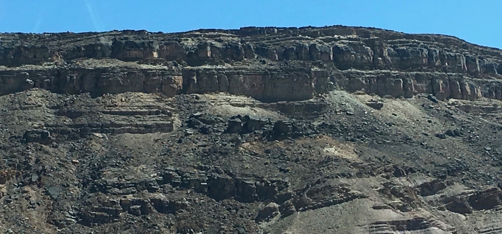
The pictures above show the igneous rock (volcanic rock) that forms one range of mountains in the most southerly section of Namibia.  The rocks are largely granites.  
Most of the rock fracturing (in the top 2 pictures especially) is caused by rain freezing in cracks in the rock and hydraulically pushing the pieces apart.  


Driving past the area above it looked like a conglomerate rock.  A bunch of rock "glued" together by sand and pressure.


On both of the mountain faces above you can see areas of metamorphosis that has occurred.  In the top picture it is in an igneous rock face; in the lower one it is in a sandstone face.  It is the area that looks "bent down" right in the middle.  This is caused by the heat and pressure of rock that used to be on top of it.


The 3 pictures above kind of look like the Grand Canyon in shades of brown to gray brown to dark purples instead of sand, ochre, oranges and reds.   These are sandstone cliff facing but the basic igneous rock that make up the sandstone has a different chemical composition than the Southwest US.  The greenery is because the border between South Africa and Namibia is the Orange River (Oranje Rivier in Afrikaans)


As you see after the Orange River you enter into the first of the two Greater Deserts in Namibia - The Namib Desert from which the country gets its name.  The other desert farther north and east of the Karas Region (of which Keetmanshoop is the capital) is the famous Kalahari Desert


The above 2 pictures are the ones that remind me soooo much of the "miles and miles of miles and miles" of West Texas fame.  Semi-arid land with its very own variety of "sagebrush" (it isn't actually sagebrush but it sure looks like it as you drive by.

We came to Keetmanshoop this time because the last time we were here 3 years ago Irene told the church if we ever got to come back again she would do some teaching with the kids.  So, she put together a "Super Saturday" for the church kids -- 5 lessons in one day: Noah, Abraham, Jesus in Gethsemane, Jesus' Death on the Cross and Jesus' Resurrection.  Additionally, today she taught the ladies at a "Ladies Day" with the Theme "Can Christ Be Seen in Me?"

The Super Saturday went really well.  There was true culture shock for Irene when she gave out activities that had stickers on them.  The kids had never seen or used stickers before.  They didn't know what to do.  A teenage girl told Irene that something like stickers was "a once in a life time experience for them!"  I guess even SHE had never used them before then.  The kids had a great time.  The total session was 2 1/2 hours long.  Irene said they were the best behaved kids she had E-V-E-R taught.  They were totally enraptured by the pictures of each of the five stories that she projected up on the wall.  They don't have a movie theater in town (or within 125 miles), so seeing pictures THAT BIG on the wall was amazing.  They hung on to every word she spoke and were as quiet as a church mouse. 

We also did some other teaching on the family -  Sandra and Rohan had separate classes for the men and ladies on "Is Christ Seen in Your Home?"  I had a very frank class on keeping yourself sexually pure for the teens and young adults.  I also taught on "Bringing Hope to the Hopeless" - (i.e. - the need to be evangelistic) and tomorrow morning the class I'm teaching is on "The Church's Hope for the Future - Raising Believing Children."

We head back to Cape Town tomorrow after morning services and will stay the night along the way (It's a 12-14 hour drive straight through which we do NOT want to do). So, we will arrive in Cape Town on Monday in the afternoon.  Do our laundry (maybe) rest for a while and then on Tuesday we leave Cape Town to fly back to Mission, Texas via Johannesburg, South Africa; Madrid, Spain, Chicago, Illinois and Dallas/Fort Worth, Texas.  We arrive in McAllen, Texas LATE on the 5th.  We do our laundry (if not done in Cape Town); Get the mail that's been held for a month in Florida at our mail forwarding service); Rest for ONE DAY (the 6th) and then fly to Highland, California to take part in our first sojourn of the year.  I will preach the gospel meeting as part of the sojourn that actually begins tomorrow.