Thursday, April 28, 2016

Odds and Ends before we are "Lost in Space"

We need to tell you that we are now in Canuckia.  Tonight we are in McLure at Pinegrove Campground.  McLure is about 25 miles north of Kamloops.  Whenever we travel we try to put big cities in our "rearview" mirror - Get through them so the next morning we don't start the day facing a traffic jam.  Now, you'd think that Kamloops, British Columbia, Canada CAN NOT have traffic jams, right?  You'd be wrong.  We just came back from town and faced a 3/4 mile wait for a traffic signal.  Thank goodness we weren't turning that direction.

We left Cascade Locks/Portland East KOA Monday morning.  On the way out we had a confrontation with a stump that they hadn't ground down. "WHAT WAS THAT!!," as I slammed on the brakes.


OUCH!!

So, that will be repaired at Red Bay in Nov/Dec.

Odds and Ends #1:

We traveled California from South to North to East to West.  We entered Cali on I-8 and could LITERALLY see the fence along the border with Mexico about 1/4 mile from the Interstate - That's both about as far SOUTH as you can go in California AND as far EAST as you can go in the state of California.  We drove around looking at our previous residences and drove on the Pacific Coast Highway - right against the Pacific Ocean.  Also, we drove right along the Pacific Ocean in Eureka, California.  That's almost as far WEST as you can go in California.  Then, after visiting and having a Sojourn at Yosemite Bible Camp (which is in the Sierra Nevadas which are on the border with Nevada), we drove out the NORTHERN border of California on US Highway 97.

Odds and Ends #2:

We drove through the Imperial Valley to see the Salton Sea and the San Andreas fault that ends along its eastern shore.  Going through the Imperial Valley and were amazed to see all the farming that is done in that area - Date Palms, Almonds, Fruit and Vegetable fields.  But that was N-O-T-H-I-N-G compared to the farming that is done in the Central Valley of California that we drove through from Grapevine, CA to Stockton, CA going to and leaving the sojourn at Yosemite Bible Camp.

The Central Valley of California.  The central valley comprises LESS THAN 1% of the land area in the United States.  Now, look below at the percentage of TOTAL % of crops produced in this small amount of land (relative to the total area of the USA):


Odds and Ends #3:

The central entry point to the Alaskan Highway is Ellensburg, WA. This happens to be the city that I went to college in.  It was a college that began in 1891 as "Washington State Normal School."  It was a teacher training college.  In 1937 it became Central Washington College of Education.  By the time I attended - 1970-72 it had been renamed "Central Washington State College" (That happened in 1961).  In 1979 it was redubbed for fourth time - this time as Central Washington University.  So, I showed Irene around the campus.  The dorm I was in was still there - Munson Hall.  It's an original building of the campus, so it's on the National Historic Registry.

Odds and Ends #4:

We crossed the border at the Oroville (US)/Osoyoos (Canada) Border Crossing.  It went pretty quickly:


Final Note:

Going through the rest of British Columbia and into the Yukon Territory and Alaska.  I can't promise how many posts we will be able to have over the next 2-3 weeks.

Monday, April 25, 2016

One Hood Beats Three Sisters and a Jefferson

So, today children we will be studying Volcanology.  Volcanology is the study of Volcanoes.

There are 2 basic types of Volcanoes - Stratovolcanoes and Shield volcanoes.  Technically, there is a third.  It is a hybrid of these 2 - a Composite Volcano.
Stratovolcanoes have the classic "volcano look" - kind of like a cone with the top cut off of it.  This is because the lava (it's called "magma" while still in the volcano and "lava" once it comes out) is thick, so it runs down the sides of the volcano more slowly and has time to cool and begin to harden on the way down.  It's kind of like a candle in a way.  The wax keeps building up and up on and around the candle as it cools.

A Shield volcano doesn't typically get as high as a stratovolcano because the lava is thinner and "runnier."  It tends to flow more quickly and not build up as much because it just keeps moving.  It more easily obeys the law of fluid dynamics - "Liquids seek to find their own level."

Composite Volcanoes result when the magma inside the volcano's cauldron changes chemically and is thicker at times (tending toward stratovolcano magma) and thinner at other times (tending toward shield volcano magma).  

The Cascade range of Northwestern America is part of the Pacific Ocean "Ring of Fire."  This ring of fire is caused by the fact that the "Tectonic Plates" which float upon the liquid core of the earth are moving.  This causes them to collide and crash.  Some of the plates are pushed UNDER other plates.  This is called a "Subduction Zone." HEY! YOU IN BACK - WAKE UP! THIS WILL BE ON THE TEST!! 

Anyway, you know how your hands get warm when you rub them together?  This is because of friction.  Friction generates heat. Now, take something as large as the floor of MOST of the pacific ocean and SHOVE it underneath of the state of Washington, Oregon and Northern California.  What happens - The land that is Western Washington, Western Oregon and Western Northern California gets pushed up.  This PUSHED UP part is called the Cascade Mountains.  Also, LOTS AND LOTS of heat is generated by the friction caused by all those plates of earth rubbing against one another.  It gets so hot that the actual rock itself begins to melt.  This melted rock collects in fissures in the ground and causes pools of melted rock (magma).  Eventually this pool grows and just like that ZIT you had at the end of your nose at 16 it POPS! VIOLA - a volcano is formed as this magma under pressure erupts out onto the land as lava around the crack.  If it is thick lava it begins to build a stratovolcano.  If the magma is thin it begins to spread out on the land and forms a shield volcano.

We drove Thursday from Weed, California (where Mount Shasta is) to Portland, Oregon.  During this trip we saw numerous volcanoes. I wanted to share some of those pictures with you in this blog post.


First another picture of Mount Shasta:


Next Mount McLoughlin:


Next is the BACKSIDE of Crater Lake (that a one time was Mount Manama).  This is called "Mount Scott":


Next was "Three Sisters."  This is three volcano "vents" probably from a very large magma chamber.  Two of them are stratovolcanoes and the third is a composite:


Unfortunately, we couldn't get a really great shot of these three beauties.  They are behind a lot of trees as you travel on US Hwy 97 north, through Oregon.  Since we were towing our car behind the Trekker, we couldn't just pull off on any road we wanted to go get a great pic.  It's tough to turn around a 64 foot vehicle.

Next up was Mount Jefferson:


Next is Mount Hood the highest of all of Oregon's Volcanoes:


Finally as we approached I-84 at the North of Oregon along the Columbia River we could see Mount Adams ACROSS the river in Washington State:


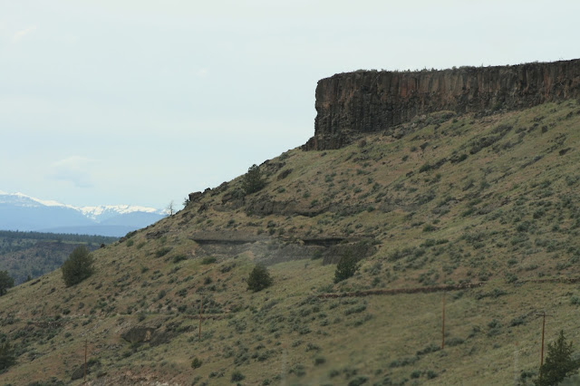
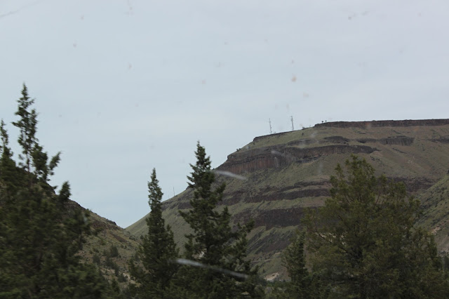
A couple of more pictures from a volcanology perspective.  Coming toward the north of Oregon from the south out of Madras you come through the most beautiful Basaltic Lava flows.  They are hundreds of feet thick and look like the Badlands of North and South Dakota.  Mesas rise from the floor of the landscape.  Butte sink down INTO the landscape.  These were buttes.


Each"Layer" is represented by a separate dark set of cliffs.  In the second from the bottom you can see a single flow on top that is probably 100 feet thick and a darker color than the ground under it. In the bottom picture I can count at LEAST 7 separate flows of lava indicated by the different dark bands with an angle and grass marking the boundary.

Wednesday, April 20, 2016

Three Musketeers?

We took a trip from Mt. Shasta, California up to Crater Lake in Southern Oregon today.  During our trip we saw three volcanoes.  This post will be a series of pictures about those volcanoes.

The first is Mount McLoughlin.  It is a composite volcano.  It is 9,495 feet in elevation.


If you'd like to know more about Mount McGloughlin, click here.

Crater Lake was formed by a volcano (the Indians called it Mount Mazama) that exploded and collapsed in on itself about 7500 years ago.  Below are the photos we took of it and the boards that explain the events surrounding its implosion.


If you want more information about Crater Lake - Click here and here is the National Park Service Page about it.

The third volcano we saw is Mount Shasta.  As I mentioned in yesterday's post, Mount Shasta is the 2nd highest Volcano in the Cascade Range.  Here's a bunch of the pictures we took beginning with board to explain some about Mount Shasta:


Obviously beautiful beyond description.  Click here for the wikipedia article on Mount Shasta.  Click here for the National Park Service page on Mount Shasta.


Bye Bye Big Boys OR Holy Moley, What's THAT?

We left Eureka and the land of Giant Redwoods yesterday to head toward Oregon via Mount Shasta.  We came over on California Highway 299.  It follows the Mad River out of the California Coastal Range and then on the other side follows the Trinity River.  It was really nice.  The road was MUCH nicer than I thought it might be.  They are doing a fair amount of work on it, so in a couple places we got held up for 10 minutes or so ... one time for 19 minutes.

As  you know if your keep up with our blog, I was a geology minor in college.  So, all things geologic fascinate me.  Mount Shasta (elevation 14179) is the southern Cascades and 2nd highest volcano in the Cascade Range (Mount Ranier in Washington at 14,411 feet is the biggest boy on the block).  It is an active volcano, though it hasn't erupted in recorded history - so it's called "potentially active."  I had to see it and get pictures.

Today we head for Crater Lake - an "Extinct" volcano in Southern Oregon.


Tuesday, April 19, 2016

We Are as Grasshoppers in Their Eyes OR What's the Fixation on Vicky

Today we went down to Humboldt Redwood State Park and drove the "Avenue of the Giants."  It is a 31 mile section of old, two lane US Highway 101 that winds its way through numerous old growth Redwood Groves.  Of the 31 miles fully 25 of them are through actual Redwood Groves.  I'm going to just put a bunch of pictures of the road through the forest to give you a touch of the sense of how overwhelming it is to be in the midst of miles and miles of monster Redwood.  Here you go (I'll be back with more at the end of your "drive.")


Hi!, Your drive is over and you're now ready to "Walk among the Giants."  

Prepare to feel dwarfed, awed and overwhelmed.  In many of the pictures below Irene or I are standing in the picture to give you a sense of perspective:


ABOVE: You see many trees that have fallen.  They are being "reclaimed" by the forest: slugs, moss, ferns and sometimes other trees are using the fallen tree as nutrients for their own growth


ABOVE:  Look REALLY closely, Irene is standing a just to the right 
of the tree in the middle of the photograph


ABOVE:  From the roots, this tree had to have been about 16-18 feet MINIMUM in diameter when it came crashing down.  Jim is somewhat in front of it making him look taller in reference to the tree and he is 6'2" tall.


ABOVE: Irene is standing in front of the "Founders Tree."  Below are its "vital statistics."  Please notice the height - 346.1 FEET TALL.  To give you some perspective - a football field is 100 yard long - That is 300 FEET.  Each end zone is another 10 yards deep - another 30 FEET.  So, this tree is as tall as 1 FOOTBALL FIELD is long PLUS 1 1/2 of the end zones too!!


ABOVE: Also, notice that you have to shinny up 190.4 feet (from your goal line to the to your opponents 37 yard line) to reach the first branch on this tree.  OH, this is a tall one, but 35 feet short of the TALLEST redwood.


2 Pictures ABOVE:  Irene standing INSIDE a burned out tree.  This tree is still quite alive!  Every year it put forth it little "Redwood leaves." This is the result of a natural fire.


ABOVE: Sometime relatively recently this tree "fell down and went BOOM!"  Notice that the wood where it's been cut is still very "reddish."  Over the years as it oxides these cuts will turn dark brown. This tree is about 7 feet and diameter at this point.


ABOVE 2 Pictures:  A 9 foot in diameter tree that has fallen.


OK, so now you are ready to see the "Dyerville Giant" that fell in 1991.  It was a very big tree.  Over 370 feet tall (a football field, both end zones and a little bit more in height).  The Dyerville Giant registered on local seismographs as it fell to the ground people a mile away thought that a train had crashed.


ABOVE:  This shows the "root ball" of the Dyerville Giant.  About 4 feet of it can't be seen because it is below the ground level where Jim is standing.  You can see it looks to be about another 2 "Jim's" high.  That would be Jim + 2 Jims + 4 feet more or about 22 feet in diameter at the base.

You'll notice that the trees that have fallen over don't go very deep into the ground.  Redwoods do NOT have a "Tap Root" like most trees.  They rely on growing their limbs to "balance" themselves as they grow.  First off, they don't grow where there is a lot of top soil and trying to penetrate solid granite is a non-starter.  Secondly, they grow where it is VERY moist (the coastline of Northern California) where there is typically a LOT of rainfall so the roots don't need to go "deep" to find water).


ABOVE: Strictly an attempt to show much of the length of the Dyerville Giant on the ground.

Below are a couple of interesting pictures.  What happens when one 200 foot plus Redwood falls at an acceleration rate of 32 feet/second/second (the pull of gravity toward the earth) on another 200 foot Redwood and a 275 foot plus Dyerville Giant that has already fallen?


REDWOOD TOOTHPICKS 
FOR PAUL BUNYAN!

ABOVE:  As this tree fell in 2007, it fell across the tree that had already fallen just below the midline of the top picture. It cracked and then fell over the Dyerville Giant which is laying about 10 feet behind Jim in the bottom picture.  This broke the tree PAST the Dyerville Giant off BUT reflected the energy between the two trees BACK toward the first trees.  This reflected energy caused the explosion of the part of the falling tree that was between the two trees already on the ground.  Man, what an awesome study in wave mechanics.

So, on our way back to the rig we went through historic Ferndale.  Ferndale started to be settled right smack dab in the middle of Queen Victoria's reign (June 1837-January 1901).  So, almost the whole town is built in the Victorian Style.  Below are a bunch of pictures of these very well preserved Victorian Homes for your appreciation without comments: