So, I found out I gave out some bad information and I wanted to correct it. In our last post I said (2 or 3 times that I thought the blacker mountains on the North American Plate side of the Denali Fault were probably Basaltic in composition. As an NFL Referee would say "Upon Further Review....".
It ends up that the composition of those mountains is a sedimentary silt stone conglomerate called "Kahilta Flysch." The primary composition is indeed basaltic in origin, but I thought they were igneous basalt (volcanic in origin) and they are sedimentary basalt. To those of you who may be big-bang non-believers or deists that may make millions of years of difference; to those of us that are creationists, it is a distinction without a difference essentially because God made the dry land appear (in all it's constituent forms - igneous, sedimentary and metamorphic) within the same 24 hour period on day 3:
"Genesis 1:9 And God said, Let the waters under the heavens be gathered together unto one place, and let the dry land appear: and it was so. 10 And God called the dry land Earth; and the gathering together of the waters called he Seas: and God saw that it was good. "
At the same time God miraculously created these things he also put into effect the Physical Laws of Nature that have operated as we presently know them since that time.
Lest you think me the fool for believing (having faith) in the literal Bible account of creation contained in Genesis 1, let me point out that those that are believers in the "Big Bang" theory run into their own philosophical and scientific "leaps of faith."
1.) The laws of Physics (Conservation of Mass) state that "matter can neither be created nor destroyed" -- So where did the original Matter in the "Big Bang" come from?
2.) The consensus of Scientists is that the laws of nature AS THEY NOW EXIST had to NOT exist and be TOTALLY DIFFERENT - (Because the present laws of quantum mechanics don't hold up) - so you are forced to believe in Planck's Epoch, a "Singularity," "Quantum Loops," or "Big Bounces"or any one of a growing myriad of explanations of how the "something" in which we presently exist came from "nothing."
The point is we all ultimately have "faith" in something. That "something" is Eternal: For the Christian it is God; for the Non-Believer it is Matter itself (that is Stephen Hawking's latest proposition). Having said that, two things are for sure -
1.) NONE of us was there.
2.) The Christian doesn't have to "set aside" the very laws which we all know are presently in effect. We state God created the universe as it presently exists and the laws which we presently have.
Thursday, May 26, 2016
Tuesday, May 17, 2016
Denali Flyover
Last night we did a flyover f Denali. It was breathtaking. There were 4 of us that went. Irene and I and separately (and someone that we'd never met before) Ximena and Eduardo. Ximena is a professor at (drumroll here) PURDUE UNIVERSITY!! Eduardo is her father. How totally bizarre. We lived in West Lafayette (the town Purdue is in) and Lafayette for 32 years. She moved there in 1997 and she and her family have moved into a house 2 blocks from where we lived in West Lafayette. So, where do we meet? Denali National Park - 2919 miles from here as the crow flies.
Denali National Park USED TO BE CALLED Mount McKinley National Park. Mount McKinley is the highest peak in North America at 20,308 feet (For you international JITREKKING fans that is 6189.878 meters). It was renamed Denali National Park in 1980 by Jimmy Carter. Denali is the Athabaskan word for "The High One." The Athabaskan people are the Native Americans that have lived in Alaska since the beginning of recorded time. At the same time it was renamed Denali National Park they expanded the size of the park from 2 MILLION ACRES to 6 MILLION ACRES! That's a B-I-G park! The biggest in the world. Alaska itself is almost the size of 1/5 of the 48 contiguous United States. And Denali is about 1 1/2% of Alaska's total area.
I thought I'd share some of the Videos and Pictures we took on our flight. First, below is a map of the path our flyover took.

If you look at the upper right hand corner of the map you will see from where we took off and landed. The arrows indicate the direction of our travel. Our flight last about 90 minutes. We flew in a Cessna Navajo, a 2 engine (turboprops at that) plane.


Denali National Park USED TO BE CALLED Mount McKinley National Park. Mount McKinley is the highest peak in North America at 20,308 feet (For you international JITREKKING fans that is 6189.878 meters). It was renamed Denali National Park in 1980 by Jimmy Carter. Denali is the Athabaskan word for "The High One." The Athabaskan people are the Native Americans that have lived in Alaska since the beginning of recorded time. At the same time it was renamed Denali National Park they expanded the size of the park from 2 MILLION ACRES to 6 MILLION ACRES! That's a B-I-G park! The biggest in the world. Alaska itself is almost the size of 1/5 of the 48 contiguous United States. And Denali is about 1 1/2% of Alaska's total area.
I thought I'd share some of the Videos and Pictures we took on our flight. First, below is a map of the path our flyover took.
If you look at the upper right hand corner of the map you will see from where we took off and landed. The arrows indicate the direction of our travel. Our flight last about 90 minutes. We flew in a Cessna Navajo, a 2 engine (turboprops at that) plane.
Above: Denali is in the "Alaskan Range" an extension of the Rocky Mountains as they extend back into Alaska from British Columbia and the lower 48. At the end of the video you can see a long glacier in the middle of the screen from bottom to about 1/2 way up.
Above: This video starts by looking at a Basalt Peak and then zooms in on the glacier
between it and the next ridge line on the left of the video.
Above: some of the mountains at the base of Mt. Denali. The video ends with our
first peak at the summit of Mt. McKinley (Denali).
Above: A video where I try to keep Mount McKinley in the center top of the
frame and zoom in and then out from it again.
Above: This short video begins by showing the lighter colored granite on
the Pacific Plate side of the Denali fault then pans across a glacier to the
Darker Basaltic Peaks on the Alaskan side of the Denali fault.
Above: A closer look at the shear face of one of the granite mountains
Above: The video scans across a glacier and onto the face of a granite mountain
Above: A view across the Basaltic section of the Alaska Range. It ends looking
at a glacial floe on the right of the video.
Above: This isn't a "really dirty" glacier. This is a run-off river. It riverbed is made of of glacier crushed basalt. The snow filled lines indicate the course the river has flowed. Each line indicates a different year. Because more and more crushed rock get deposited here every year by the glacier (up and the the right in the video) the water runoff has to cut a different course every year. Liquids always take the "path of least resistance."
Above: This video opens looking at a rusty brown mountainside. This rusty brown for a reason - it IS RUST. Iron ore and other minerals (Gold, Coal, Copper) is what brought the original Caucasian settlers to the Denali area.
Now some pictures we took during the flight. I thought I took a lot - 189. Irene did her usual twice as many - 336. Her's are better, she had the perfect lens - a 50-200 mm. I on the other hand had our monster 200-500 mm lens. We both have Canon EOS Rebel cameras. (The videos above were taken on my iPhone).


Above: The somewhat apprehensive flyers before take off.


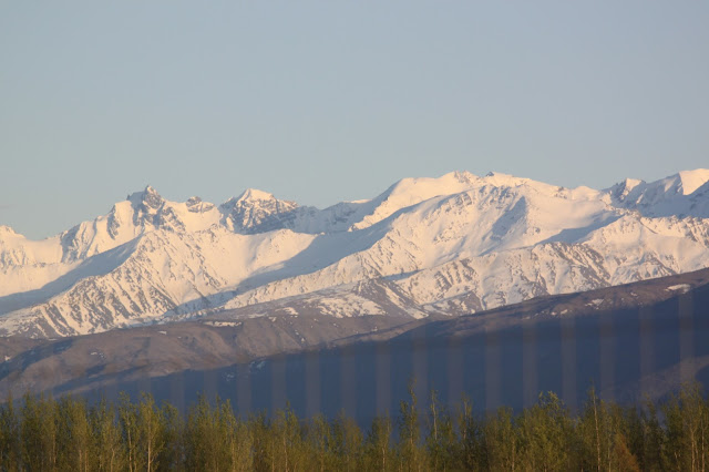
Above 3 pictures: The mountains just go on and on for miles and miles.


Above 2 pictures: It looks like virtually nothing as you see it here, but that line across both pictures about 1/3 of the way up is one portion of the Denali Fault Line where the mountains above the line are being pushed under the land below that line by plate tectonics. The Pacific Plate is being pushed under the Alaskan plate. There are hundreds of earthquakes every year along the fault. Most are minor in the 2-3 on the seismic scale.

Above: A picture of the Nenana River and the Alaska Railroad taken just after take off.

Above: A closer look at the "Rusty" Iron Ore that makes up the top of this mountain peak.

Above: A closer look at the face of a Basaltic Mountain

Above: A closer look at the face of a Granite Mountain


Above: Two pictures showing crevices in the front near the face of glaciers.
These are hundreds of feet deep and as much as 100 feet wide.


Above 2 pictures - Water pooling on top of glaciers.


Above 2 Pictures: The front faces of 2 glaciers. Notice the deep green and blue.
Moraine is the crushed rock that is being carried by a glacier. Some of this is at the edges of the glacier. This is called "Lateral (along the side) Moraine."

Above: Lateral moraine at the base along the mountain on the left of the picture.
There is also all the rock that has been sheared off and is at the end of the glacier and gets dumped every year it warms and the glacier retreats some until the next winter's temperatures and snow cause it to advance again. This is called "Terminal (at the end) Moraine"

Above: You see the dark, dark terminal moraine of a glacier and the somewhat lighter runoff stream between it and the mountains on the right side of the picture

Above: When 2 glaciers meet they "combine" their terminal moraine in the middle of the composite glacier. Here it looks like "snakes"in the middle of the glacier. This is called "Medial (in the middle) Moraine"
Below: Are the Mount Denali/Mount McKinley
"money shots" by Irene and I.


Below: The Blown Away, slightly relieved travelers after
their "bucket list" Denali Flightseeing tour.

Thursday, May 12, 2016
o/' o/' "Shake, Rattle and Roll" o/' o/' OR o/' o/' "Back in the US, Back in the US, Back in the US of A" o/' o/'
First off, I know the Beatles Song title is actually "Back in the USSR" but humor me here people, this is OUR blog!
We are indeed back in the US of A's northern frontier. At least I THINK this is the USA. I'm kinda unsure after our first trip to the grocery store where we saw these items on the shelves:


Anyway, the drive which if it was on a good road would have taken us 4 or so hours took us 6 1/2 hours. That one stretch of 9 miles took us a single hour to cover. You just sit and imagine yourself being massaged by the road as you are "shaken, not stirred" and putt, putt, putt along. There were also 3 or 4 other sections that were from a couple hundred yards to a couple of miles where the road surface was just dirt with some stone on it and MAYBE had been graded at some point.
We arrived in Border City, Alaska about 2:15 that day. "Border City" is 2 businesses - A Lodge/fuel stop/RV park and a liquor/grocery store, that's it. I think that it exists so Canadians that live close enough to the border can come over and get cheap(er) gas and liquor and then go back home. Canadian fuel was C$ 1.08 per liter. There are 3.85 liters in a gallon. So, that is C$ 4.15 per gallon. The exchange rate while we were in Canada was $1.00 US = $1.25 Canadian. So, the gas at this place really wasn't any cheaper in reality because of the exchange rate. Plus, the gas they get there is trucked in from Canada anyway.
The next morning we left Border Town, AK and drove to Delta Junction. We got here Tuesday afternoon. Here we had to stall our trip. We had hoped to just keep going up to Fairbanks and then down to Denali. What we found though is that none of the RV campgrounds in Fairbanks or Denali open until at LEAST May 15th. It's because they never know when they will have a cold winter that lingers until late April. So, their "season" begins from May 15th to June 1st depending on the RV park. Even here in Delta Junction, though the RV park is "open" the water isn't turned on yet. Sooooo, everyday Irene washes clothes we have have had to disconnect our electric and sewer and drive to the main house to refill our fresh water tank; drive back to our site and reconnect, relevel and put out our slideouts again. It's kinda like a good shampoo - wash, rinse, repeat!
Last night was special - we went "Moose Hunting" and "bagged" two of them (strictly speaking photographically for all you animal rights wackos that just had a coronary).


We also got to see some Cariboo on the trip from Haines Junction. It was a "nuclear family" - Dad, Mom and kid. Here's a couple of shots of those:


We are indeed back in the US of A's northern frontier. At least I THINK this is the USA. I'm kinda unsure after our first trip to the grocery store where we saw these items on the shelves:

Then, on our first drive out in the countryside around Delta Junction, Alaska we see a church with the sign below in its front yard.


So, yes, we very well may actually be "Back in the USSR."
(Please notice that all of that was said without animus and without reference to the present administrations Stalinification of America.)
So, we left Haines Junction, Yukon to head to Alaska this past Monday morning. This was the BAD part of the Alaska Highway -- it is legendary for its roughness. From Haines Junction to Border Town, AK is about 190 miles. This would typically take about 4 hours on a decent road. To this point the WHOLE of the Alaska highway has been at WORST "decent", at best "very good." It was like a good 2 lane state highway in America. But the Haines Junction to the border section is "good" at best to "OH, MY WORD" at worst. There is one 9 mile section of the "highway" where they are reworking on the surface. They took it down to the dirt below the surface, then graveled it as a base for the road and "THAT'S ALL FOLKS!" as Porky Pig used to say at the end of a Warner Brothers cartoon. So all of these cars and trucks have been over it for at LEAST 2 years with there chains on in the winter. It is TOTALLY WASHBOARD now. You feel like you are being shaken to death even at the 20-30 mph you can even begin to tolerate driving. It is a true vehicle stress test. Especially for a house on wheels. Which reminds me of a joke:
Friend to Motorhome Owner: "What kind of milage do you get while driving that?"
Motorhome Owner: "About 5-7 miles per gallon."
Friend to Motorhome Owner: "That's horrible!"
Motorhome Owner: "It isn't bad for a house!"

Above is a picture of the "Washboard" section of the Alaska Highway near
Destruction Bay (yep that is its ACTUAL name).
Anyway, the drive which if it was on a good road would have taken us 4 or so hours took us 6 1/2 hours. That one stretch of 9 miles took us a single hour to cover. You just sit and imagine yourself being massaged by the road as you are "shaken, not stirred" and putt, putt, putt along. There were also 3 or 4 other sections that were from a couple hundred yards to a couple of miles where the road surface was just dirt with some stone on it and MAYBE had been graded at some point.
We arrived in Border City, Alaska about 2:15 that day. "Border City" is 2 businesses - A Lodge/fuel stop/RV park and a liquor/grocery store, that's it. I think that it exists so Canadians that live close enough to the border can come over and get cheap(er) gas and liquor and then go back home. Canadian fuel was C$ 1.08 per liter. There are 3.85 liters in a gallon. So, that is C$ 4.15 per gallon. The exchange rate while we were in Canada was $1.00 US = $1.25 Canadian. So, the gas at this place really wasn't any cheaper in reality because of the exchange rate. Plus, the gas they get there is trucked in from Canada anyway.
The next morning we left Border Town, AK and drove to Delta Junction. We got here Tuesday afternoon. Here we had to stall our trip. We had hoped to just keep going up to Fairbanks and then down to Denali. What we found though is that none of the RV campgrounds in Fairbanks or Denali open until at LEAST May 15th. It's because they never know when they will have a cold winter that lingers until late April. So, their "season" begins from May 15th to June 1st depending on the RV park. Even here in Delta Junction, though the RV park is "open" the water isn't turned on yet. Sooooo, everyday Irene washes clothes we have have had to disconnect our electric and sewer and drive to the main house to refill our fresh water tank; drive back to our site and reconnect, relevel and put out our slideouts again. It's kinda like a good shampoo - wash, rinse, repeat!
Last night was special - we went "Moose Hunting" and "bagged" two of them (strictly speaking photographically for all you animal rights wackos that just had a coronary).


The top two above are the same moose and the bottom 2 are the 2nd moose we "shot."
We also got to see some Cariboo on the trip from Haines Junction. It was a "nuclear family" - Dad, Mom and kid. Here's a couple of shots of those:


We've also seen more of the awesome grandeur of God's creation. I will close this blog post with a bunch of pictures we've taken:


Subscribe to:
Comments (Atom)